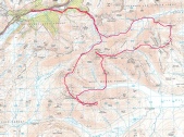
Loch Monar

The hills south of Glen Carron that encircle Loch Monar are splendidly remote and have the reputation of being some of Scotland's most isolated and inaccessible hills. Steven Fallon's route is a long one that covers all of the six Munros in this area. Even with a long summer day I needed to shortened this by cutting out the climb to the top of Moruisg at the end of the day. It was still a long and challenging walk though.
|
Bidean a'Choire Sheasgaich |
945m |
| |
|
Lurg Mhor |
986m | ||
|
Sgurr Choinnich |
999m | ||
|
Sgurr a'Chaorachain |
1053m | ||
|
Maoile Lunndaidh |
1007m | ||
|
date climbed |
24/06/2011 |
time taken |
14 hours |
|
distance |
30 miles |
ascent |
14500ft |
|
OS Map |
Landranger 25 |
Weather |
Fair with generally good visibility |
|
Starting point : Craig GR092120 | |||

The excellent forestry road that leads from Craig into the heart of these mountains
was followed. I was joined at jump off point from the road by Roy on his mountain
bike. We headed off into the hills together to climb the Corbett, Beinn Tharsuinn
that stands in the way to the first Munro of the day, Bidean a'Choire Sheasgaich.
The hard work of climbing was helped enormously by the steady conversation flow -
At the Bealach an Sgoltaidh the way up looked interesting but the path worked its way easily through the broken cliffs and rocky crags until the a fine ridge lead to the summit. The descent and ascent to Lurg Mhor is rocky but not as engaging the previous ascent. The hard work of the morning was rewarded with fine views towards Skye and Torridon as well as the Straffarar and Mullardoch hills.
After returning to the bealach between Lurg Mhor and Bidean a'Choire Sheasgaich,
grassy ground lead down to the foot of Sgurr na Conbhaire. The trudge up Sgurr na
Conbhaire is relentless -
The climb up Sgurr a'Chaorachain was a very quick affair on grassy slopes The old trig point is encircled by a bouldery line of stones with excellent views in all directions.
The ground underfoot gradually became more grass covered and wet as I dropped down
to the An Crom-
The descent down to River Meig was a bit tricky with the need to avoid some deep stream canyons that were in the way of the direct route. Finally, after what seemed an eternity, the river was crossed without getting wet feet. The stalker's path lead east of Glenuaig Lodge, the forestry road and finally, after a very long day back at Craig.
|
Moruisg |
928m 3045ft |
| |
|
date climbed |
25/06/2011 |
time taken |
5 hours |
|
distance |
7 miles |
ascent |
3400ft |
|
OS Map |
Landranger 25 |
Weather |
Fair but with limited visibility |
|
Starting point : A 890 west of Loch Sgamhain Glen Carron | |||
After the previous day considerable efforts over the five Munros in the Monar area,
the climb of Moruisg and its sister and de-